Tuesday, February 13 2024 by Salim Maula Adli
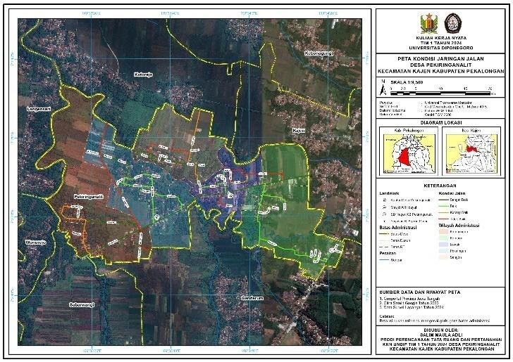
The road network condition map and infrastructure map of Pekiringanalit Village, Kajen District, Pekalongan Regency, was made from January 15 to February 7, 2024. The map was created to update village infrastructure data and improve the management of existing facilities and infrastructure.
Submit the Pekiringanalit Village Road Network Condition Map to the Pekiringanalit Village Secretary. Source: Documentation of Pekiringanalit Village KKN Team 1. Source: Documentation of Pekiringanalit Village KKN Team 1
One of the Real Lecture Work Activities (KKN) of Diponegoro University Team I was carried out in Pekiringanalit Village, Kajen District, Pekalongan Regency, Central Java Province. Pekiringanalit Village covers quite a large area in the Kajen District, consisting of provincial roads, regency roads, village roads, and farming business roads (JUT). The map creation was created to update village infrastructure data and improve the management of facilities and infrastructure owned by Pekiringanalit Village. Map creation was carried out using the ArcMap mapping application.
10.8. creating a road network condition map begins with a ground check using the Avenza, Measure, and Camera applications to document road network conditions. The survey was carried out by mapping all the roads in Pekiringanalit Village, paying attention to the physical condition of the streets, width, and type of materials used. This information is then compiled and analyzed to create an accurate and informative map of the condition of the road network in the village.

Map of Pekiringanalit Village Road Network Condition. Source: Groundcheck, 2024

Facilities and Infrastructure Map. Source: Groundcheck, 2024
Making the facilities and infrastructure map involved a more comprehensive survey covering various public facilities and other critical infrastructure in Pekiringanalit Village. Identification and mapping of the location and condition of facilities and infrastructure such as health, education, religious facilities, and sports facilities, as well as other critical infrastructure such as water pipes, electricity, and telecommunications. This data is then analyzed for a detailed map of village facilities and infrastructure. Making a map of the condition of the road network and a map of the facilities and infrastructure of Pekiringanalit Village has a significant impact on the management of village infrastructure. The village government can plan more effective and efficient road repairs and maintenance by having an accurate road network condition map.
Meanwhile, the facilities and infrastructure map will provide a clear picture of the existence and condition of public facilities and other critical infrastructure in the village, which will be an essential basis for planning future development and development of the town. This activity is not just about making maps but is also a necessary step in improving the quality of life and welfare of the people of Pekiringanalit Village. With more accurate and informative data, it is hoped that this village can develop better infrastructure management strategies and plan development that is more sustainable and oriented towards community needs.
